Bundesländer Deutschland Karte: Dein einfacher Guide zu den 16 Bundesländern
Introduction
If you’ve ever tried to memorize all of Germany’s federal states, you’re not alone. Many people – whether students, travelers, or simply curious individuals – eventually face the question: Where exactly is each federal state located? This is precisely where the „German federal states map“ comes in.
A map not only makes everything clearer, but also much easier to understand. Instead of dry lists, you immediately see how everything fits together. In this article, I’ll show you in a simple and enjoyable way how Germany is structured – and why a map can be your best friend.
What are the federal states in Germany?
Germany is not a centrally controlled country, but a so-called federal state . This means that power is distributed among several regions – the federal states.
Simply put:
Each federal state has its own government and can make its own decisions in many areas, for example in education or policing.
Why are there 16 federal states?
This has historical reasons. After the Second World War, Germany was reorganized, and the federal states were partly created from old regions and kingdoms.
Today there are exactly 16 federal states , and each has its own unique character. Some are large and economically strong, others small but culturally fascinating.
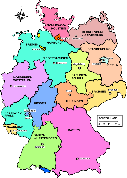
Overview: The 16 federal states of Germany
Here’s a simple overview to help you remember them better:https://de.wikipedia.org/wiki/Land_(Deutschland)
- Baden-Württemberg – known for its automotive industry and Black Forest
- Bavaria – the largest federal state, famous for Oktoberfest and the Alps
- Berlin – the capital of Germany
- Brandenburg – plenty of nature around Berlin
- Bremen – the smallest federal state
- Hamburg – a major port city in the north
- Hesse – Financial center with Frankfurt
- Mecklenburg-Western Pomerania – Baltic Sea, beaches and tranquility
- Lower Saxony – diverse with cities and nature
- North Rhine-Westphalia – the most populous federal state
- Rhineland-Palatinate – wine region
- Saarland – small, but culturally interesting
- Saxony – rich in history
- Saxony-Anhalt – many UNESCO World Heritage Sites
- Schleswig-Holstein – between the North Sea and the Baltic Sea
- Thuringia – known as the “green heart of Germany”
Tip: Imagine Germany as a puzzle – each federal state is a part of it.
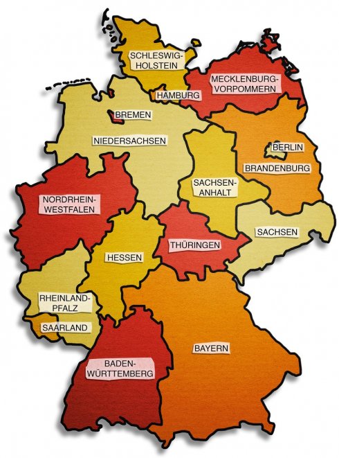
German Federal States Map – Simply Explained
A map of Germany’s federal states shows you all these regions at a glance. And that’s incredibly helpful.
What does such a map show?
- Borders of the federal states
- Names of the regions
- Often the capital cities as well.
- Color differences for better orientation
Why colors are important
Colors help your brain learn. For example, if Bavaria is always depicted in blue, you’ll remember it faster.
A small example
Imagine you’re learning without a map. You only read:
„Saxony is in the east.“
With a map you can see immediately:
- It is located next to Poland
- It borders the Czech Republic
- It is under Brandenburg
That makes all the difference.
Interactive and Digital Maps
Today you don’t even need to use a paper map anymore. Digital maps are even more convenient.
Advantages of online cards
- Zoom in for details
- Quickly find federal states
- Often with additional information
- Perfect for on the go
Who benefits from this?
- Students: Learning becomes easier
- Travelers: better planning
- For general interest: quick overview
Personally, I think an interactive map feels almost like a little game. You click through it and learn along the way.
Federal states grouped by region
To make it even easier, you can divide Germany into four large regions.
Northern Germany
- Schleswig-Holstein
- Hamburg
- Bremen
- Lower Saxony
Flat, windy, and strongly influenced by the sea.
Southern Germany
- Bavaria
- Baden-Württemberg
Mountains, tradition and good food.
East Germany
- Saxony
- Saxony-Anhalt
- Thuringia
- Brandenburg
- Mecklenburg-Western Pomerania
Lots of history and nature.
West Germany
- North Rhine-Westphalia
- Hesse
- Rhineland-Palatinate
- Saarland
Industrially heavily populated and densely populated.
With a map of the German federal states, you can immediately see these differences visually.
Why is the map of the German federal states important?
You might be asking yourself: Do I really need this?
The answer is: Yes – and more often than you think.
1. For the school
Geography is part of basic knowledge. Maps help with understanding and learning.
2. For travel
If you’re planning a trip, you’ll want to know:
- Where is your destination?
- Which German states are you crossing?
3. For general knowledge
Quiz questions, conversations or news reports – knowledge about German federal states comes up more frequently.
4. For orientation in everyday life
Whether it’s news or politics – much is regionally influenced.
Tips for learning with a map of Germany
Here are a few tricks that actually work:
1. Print the map
Hang them on your wall and look at them every day.
2. Cover federal states
Try to name them from memory.
3. Use learning games
There are many online quizzes – ideal for practicing.
4. Build mnemonic devices
For example:
Bavaria is in the bottom right – bottom like south.
5. Learn in small steps
Not all 16 at once – better to do them one by one.
I once tried to learn everything in one day – that rarely works well. Learning step by step is much more effective.
Frequently Asked Questions (FAQ)
How many federal states does Germany have?
Germany has 16 federal states.https://faktenzentrum.de/?p=2913&preview=true
Which is the largest federal state?
Bavaria is the largest federal state.
Which one has the most inhabitants?
North Rhine-Westphalia has the most inhabitants.
What is the capital city of Germany?
The capital city is Berlin.
Conclusion
The „German federal states map“ is more than just a simple overview – it’s a genuine learning tool. It helps you understand connections, orient yourself better, and retain knowledge in the long term.
Whether you’re studying for school, planning a trip, or simply want to improve your general knowledge: a map makes everything easier.
So grab a map, digital or paper, and discover Germany piece by piece. You’ll quickly realize how easy it is to find your way around and understand the federal states.


Kommentar abschicken